May 27. Biked from the campground to Taos, mostly downhill, 54 miles. Beautiful scenery and weather in the mountains in the morning, we tried to stretch this ride out as long as possible. Down on the windswept, desolate sagebrush flats between Tres Piedras and Taos, we overtook a long-haired young man walking his beat-up bicycle along the road in the same direction we were headed. Said his name was Nobody, and he was heading into Taos to get some parts for his generator somewhere up in the hills. Seems he was having mechanical problems with his shifters but politely refused our offer of assistance. Carrie noticed his water bottle was almost empty, so offered water and an energy bar. He accepted, and by way of gratitude he recited some poetry for us there on the dusty highway. I don't remember the lines, but it seemed pretty good and certainly was delivered with passion. We then parted ways and left him to trudge along to wherever he was headed. Tomorrow is a rest day seeing the Taos sights before we go up over the Sangre de Christo range. On the other side starts the great plains and the last segment of our trip.  Carrie at the Rio Grande Gorge just east of Taos.
 Carrie at the Rio Grande Gorge just east of Taos.
May 26. Debated extensively over whether to ride south to Espanola, spend the night and then northeast to Taos, or maybe go back to Chama, put our bikes on the train and take it to Antonito, then pedal down to Taos the next morning. Or, whether to do our original plan which was to travel east over 10,500 ft pass, stay the night at 9800 ft in a campground, and continue to Taos. Truth is we were pretty intimidated by the elevation, but in the end decided to do the original route. Turned out to be a great decision. Weather was cool, partly cloudy, and mostly a tailwind again, and we eventually made it to the top, with jelly legs but with plenty of oxygen. This was the biggest continuous climb we have ever done. The top was beautiful, with big patches of snow still on the ground and no traffic to speak of. At the campground spring had not yet fully arrived - the aspens were only starting to bud out and there were piles of snow still scattered around. We were just about the only ones there. Ever since the dust storm I have been having trouble with the rear derailleurs - couldn't get into the 2 highest gears and sometimes got stuck in the lowest. Didn't seem to matter much the last few days as we were going mostly uphill. However, today I got around to fixing them and now they're fine. We shared our dinner of macaroni and cheese, beer and pie with 3 extreme hikers who are walking the continental divide from Mexico to Canada, a trek of 4 months that they started 1 month ago. Sounds like quite an adventure to me. They were very grateful for the meal, and made for excellent dinner conversationalists. One of them dehydrated all his own food for the trip and rehydrates it during the day so he doesn't have to carry a cooking stove and pots, and another normally eats 3 Raman noodle packages (dry, not cooked) for his evening meal.

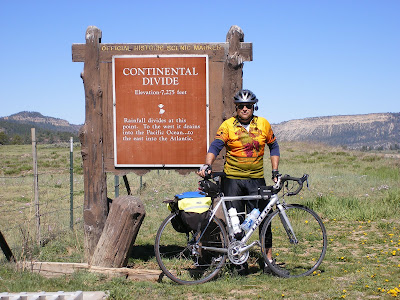
May 25. Dulce to Chama, over the continental divide which on this route is only 7850 ft. Forecast was 18 degrees in Chama, don't think it was this cold, but cold enough so we bundled up. More pretty high country. Got to Chama around lunch time, had burgers and beer in a saloon. Chama is a tiny town, not too touristy but the terminus of the Cumbres & Toltec Scenic Railroad that goes from here to Antonito Co. It just started up for the season last week. From Chama we went south ~20 miles to Heron Lake State Park and met back up with the support team.
 The continental divide in northern New Mexico between Dulce and Chama. Not too impressive by Colorado standards. The sign says 7250 but the garmin and my maps say 7750.
May 24. Packed bare essentials for motel cycling and headed to Dulce, 70 miles. Pretty road, not much car/RV traffic but a lot of gas rig service trucks, since the Farmington gas fields are south and east of Farmington along this route. Stiff tailwind, pretty country through the Jicarilla Apache reservation. Stayed the night at the Jicarilla Best Western Inn and Casino. Don't know how they stay in business, but the rooms and food were OK. Had a good night's sleep in a real bed for the first time on the trip. Turned out Joe and Lou's truck just needed some hoses replaced that were leaking coolant onto the exhaust manifold. Didn't take too long so they drove over to Heron Lake State Park south of Chama where we were to meet up with them the next day.


Loved the story about Nobody. I've run into a few characters like that before.
ReplyDeleteCongrats on cresting your Cima Coppi!
ReplyDeleteHa! Bet Nobody was from Albaquirky! LOL!
ReplyDeleteSeriously, you guys are awesome! What an adventure of a lifetime... and the pix are great. Have fun and stay safe..
Just watch, next dad is gonna want to hike the continental divide :)
ReplyDelete